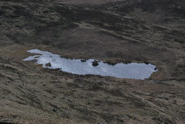
Near Flash, Axe Edge Moor, Peak District · on River Dane
A chain of clear, peat-stained pools and small gritstone waterfalls on the young River Dane, right where three counties meet under an old packhorse bridge on open moorland. The water stays cold all year and the setting is wild and remote, reached only on foot.
Three Shires Head is a string of small waterfalls and rock pools on the River Dane, gathered around and below a low stone packhorse bridge on open moorland at about 350 metres above sea level. The most visited pool, Panniers Pool, sits beneath the bridge; there is a shallower sidelong pool people use to acclimatise, a larger pool and fall about 50 metres downstream, and a quieter plunge pool just upstream of the bridge that fewer people find. This is a genuine wild-dip spot rather than a managed bathing place: there are no facilities and you reach it on foot only.
The swim is short and bracing rather than a place for lengths. Because the river rises only about 3 kilometres upstream on Axe Edge Moor, the water stays cold all year, which many visitors name as part of the appeal for cold-water dips and early-season acclimatisation. The water is typically clear but naturally peat-stained from the moorland. The bed is gritstone and boulders, so water shoes are commonly recommended.
Depth is modest and variable. Guides describe the pools as relatively small and shallow, more suited to plunging than to actual swimming, while other sources record the main pool as deeper at times, with seasonal variation. The practical point is that depth is shallow and unreliable and should never be assumed for jumping.
Entry is a wade-in over rock and boulders rather than a beach or slipway. Visitors commonly call it a picturesque, tranquil spot and a favourite Peak District wild-swim location. The main downsides on hot days are crowds and litter, so consider timing your visit if you want space.
This is a casual summer dip-and-paddle spot with a moorland-walk approach, best suited to people who want a short, cold, scenic immersion rather than distance swimming. The pools are small and shallow so it does not suit training or length swims. Confident cold-water swimmers enjoy it year-round as a bracing plunge; beginners and families can enjoy a supervised dip in settled, warm weather provided they respect the cold water, slippery rock and fast rises after rain.
Because the water is cold and the site is remote with no help at hand, a tow float and warm layers for afterwards are sensible, and swim company is wise. Non-swimmers can paddle in the shallow pool, but the moving water and slippery rocks mean close care around the falls. Do not jump or dive at any water level.
13 miles east
A stone-walled pool carved into the bed of the crystal-clear River Bradford sits in a quiet limestone valley below the village of Youlgreave, offering a cold, shallow dip among grassy meadows and little weirs. It is one of the Peak District's few river swimming spots and one of its gentlest, calm enough for families on a warm summer day.

13 miles north
A small, dark, peat-stained moorland tarn high on the western shoulder of Kinder Scout just below Kinder Downfall, with wide views over Kinder Reservoir and the plateau. A legend-soaked novelty dip reached after a long moorland walk rather than a proper swim: shallow, boggy, tea-coloured water and a wild, exposed setting.
15 miles northeast
A chain of clear, peat-stained pools beneath small gritstone waterfalls, tucked into a quiet clough on the wild northern side of Kinder Scout. It is a walk-in reward: shallow dips and cool-off plunges among the heather, far from the crowds.
19 miles northeast
A chain of clear, peat-stained pools on the infant River Derwent, where the young river tumbles over gritstone slabs into a deep plunge pool beside an old packhorse bridge. It is a reward at the far end of a long reservoir-side walk, ringed by moorland and woodland.
There is no car access to the spot itself, it is roughly 2 kilometres from the nearest public road and reached only on foot. People use three main starting points:
Satnavs do not reach the spot, mobile signal is poor to non-existent at the car parks, and the approach lanes are narrow moorland roads. Download an offline map before you go. Distances: roughly 20–30 minutes' drive from Buxton or Leek; the A54/A537 Cat and Fiddle road is scenic but busy and can be dangerous.
From the A54 laybys the walk is the shortest and mostly downhill on the way there: go through a farm gate onto a track, then a grassed footpath down the valley, following the widening stream for about 2 kilometres to the packhorse bridge. Allow roughly 30–40 minutes each way; remember it is uphill on the return with wet kit.
From Gradbach the route is a longer figure-of-eight or circular of around 6–7 kilometres, following the Dane Valley Way and field paths.
The terrain is moorland: stony, rutted paths that are boggy after rain, with gates and stiles, open fields with grazing sheep, and no shelter if the weather turns. Sturdy footwear is essential. The route is manageable with older children who can walk a few kilometres over rough ground, but it is a real walk with kit and not suitable for pushchairs or wheelchairs.
Honest verdict: this spot is not realistically reachable car-free. There is no public transport to Three Shires Head or to its car parks.
The nearest railway station is Buxton, about 11 kilometres away. The 58 bus (High Peak Buses, Buxton–Cat & Fiddle–Macclesfield) crosses the moor and stops at the Cat and Fiddle: it departs Buxton Market Place early in the morning and then roughly hourly until the evening on weekdays, with a limited Sunday service. From the Cat and Fiddle it is still several miles of open-moor walking to the falls. Guides suggest options such as a 2.5 mile walk from the Knights Table pub, but these are infrequent services across exposed high ground.
Cycling is possible on rough tracks and the approach is rideable in parts, but you still finish on foot at the falls and the moorland tracks are rocky.
Best months are roughly June to September, when the moorland approach is driest and the shallow water is at its most comfortable for dipping, though it stays cold all year. Summer weekends, hot days and school holidays bring crowds and litter, so arrive early, midweek or on a cloudy day for more solitude.
In winter the spot is quiet and dramatic but serious: exposed high moorland, very cold water, short daylight, boggy or icy paths and no shelter, so it is for experienced, well-equipped cold-water swimmers only. The dog lead restriction runs 1 March–31 July. The overriding seasonal factor is rain rather than month: after heavy rain the river rises fast and the falls become dangerous, so the pools can be unswimmable at any time of year.
Treat this as a genuine moorland river, not a paddling pool with a safety net. The River Dane rises fast after rain, so a gentle set of pools can become a powerful, cold, brown torrent within an hour of hill rain and the small waterfalls gain force; the safest window is settled, dry weather.
Depth is shallow and unreliable, and there is the temptation to jump. Do not jump or dive here, depth cannot be relied upon. The water is cold all year, so cold-water shock is a real risk even in summer. The gritstone rocks and shelves are slippery and the pools have submerged rocks and uneven beds, so water shoes and cautious movement matter.
The site is remote with no facilities and effectively no mobile phone signal, so self-rescue and prevention matter more than calling for help. The approach can be boggy after rain and the shared track is used by off-road motorcycles, so take care on arrival and departure.
Conditions change. Check the water level, the weather and the forecast on the day, and make your own call when you get there.
Swimming here is long-established and tolerated by land users, but it is not a formal statutory right. You can walk to the water on mapped access land and public footpaths, and the swim is openly described in national guides and used by commercial operators, yet the law in England does not create a general right to bathe in inland rivers and the CROW Act right of access covers walking rather than bathing. There is no byelaw or Public Spaces Protection Order banning swimming at the pools that this research could find.
Access is on foot only, along public footpaths across access land, and the route is a shared one used by walkers, cyclists, horse riders and greenlaning motorcyclists. Be respectful of other users and of private land where it appears alongside the access.
This is not a designated bathing water, so its quality is not routinely tested for swimmers. The Environment Agency classifies the river reach that includes Three Shires Head as in good health in 2019 and again in 2022, which is what you would expect of a clean, fast-flowing upland headwater.
Two important caveats. First, that classification measures ecological health, not day-to-day bacteriological safety for swimmers, so it is not the same as bathing-water sampling. Second, this is an upland, peat-draining catchment with grazing sheep, so after rain the river browns and carries whatever is on the land with it. No monitored storm overflows were identified discharging into the upper Dane immediately above the spot, and the water company for the area is Severn Trent Water; check Severn Trent's live storm-overflow map before a visit if you are concerned.
Standard river-swimming advice applies here: avoid swimming for about 48 hours after heavy rain, both for water quality and because the falls become more dangerous.
Yes, with supervision
Families and children paddle and dip in the shallow pools on warm days and the site is a popular family walk, but the water is cold, the rocks are slippery, depth is shallow and uneven so there is no safe jumping, and there are no toilets or facilities, so children need close supervision.
Some restrictions
Dogs are commonly brought but the moorland approach has rules: keep dogs on a short lead between 1 March and 31 July for ground-nesting birds, keep them on a lead near sheep, and on parts of Axe Edge Moor dogs must stay on public rights of way, so keep dogs on the paths.
Car needed
There is no public transport to the spot. The nearest bus, the 58 between Buxton and Macclesfield, stops at the Cat and Fiddle several miles away across open moor, and the nearest railway station, Buxton, is about 11 kilometres away, so in practice you need a car.
None on site
Free
Three Shires Head is a popular family paddling and dipping spot and, on a warm, settled day, a good one for families prepared for a moorland walk. Visitors describe children walking over the boulders and dipping their toes into the icy cold water, and the shallow side pool is gentle enough for supervised paddling.
Be clear-eyed about the limits. The water is cold all year, the rocks are slippery, depth is shallow and uneven so there is no safe jumping, the river rises fast after rain, and there are no toilets, no shade beyond the valley sides, no café and no lifeguard. It suits families with children old enough to walk in and be closely supervised around moving water, but it is not a toddler-friendly beach.
Verdict: good for a supervised family dip and paddle in warm, dry, settled weather; avoid swimming in or after rain and do not treat this as a substitute for a lifeguarded beach.
Dogs are commonly brought and there is no blanket ban at the pools, but the surrounding moorland has rules you must follow on the approach. On CROW open access land dogs must be kept on a lead of no more than 2 metres between 1 March and 31 July to protect ground-nesting birds, and dogs must be on a lead at all times near livestock. Parts of Axe Edge Moor exclude dogs from the open access land away from public paths, so keep dogs on the rights of way. Guides advise dogs must stay on public rights of way and on a lead at all times on this route.
There are grazing sheep on the approach fields, so livestock control is essential. For dogs in the water, remember the same hazards as for people: cold water and fast rises after rain. Blue-green algae is primarily a still-water risk and is not a specific concern for this flowing river, but avoid letting dogs drink scummy standing water. There are no rinse-off facilities at the pools; the nearest dog-friendly pubs are in Flash.
This spot is not accessible to wheelchair users or to those who cannot manage a rough, uneven, sometimes boggy moorland walk of about 2 kilometres each way, with gates and stiles and no made surface at the water. There is no step-free route, no ramp or slipway, no accessible toilet or Changing Places facility, and no beach wheelchair scheme. Blue Badge holders park free at Peak District National Park car parks such as Clough House, but that does not change the walk-in. Entry to the water is over rocks and boulders.
There are essentially no facilities. No toilets, no changing, no showers or rinse taps, no drinking water and no bins at or near the spot; visitors consistently note no visitor facilities and no loos at any point. The Peak District National Park does not provide bins on its open landscape and asks visitors to take all litter home; despite this, litter is a recurring complaint here.
The nearest refreshments and facilities are in and around Flash: the New Inn and Flash Bar Stores, plus the Knights Table on the A53. All are a drive from the parking, not walkable from the pools.
Phone signal is effectively non-existent at the spot and poor at the car parks, which matters for emergencies, so plan your safety accordingly. No lifebuoys, throwlines or on-site defibrillator were found. The nearest urgent treatment centre is Buxton Hospital UTC on London Road, Buxton SK17 9NJ, open 8am–8pm daily; the nearest full A&E departments are further away.
Three Shires Head is well used for organised and guided wild swims rather than as the fixed base of a local club. Peak Swims runs guided sessions and waterfall walks here, and Women Outdoors run regular hike-and-wild-swim events to Three Shires Head from Gradbach. The Peak District National Park Authority runs guided walks that visit the spot, and large Facebook walking groups share routes to the falls. If you want company or a guided session, look up those operators before you go.
Coordinates: 53.21356, -1.98798
OS grid reference: SK009685
Contains OS data © Crown copyright and database right
June to September
There is no postcode at the spot itself; it is roughly 2 kilometres from the nearest public road. SK17 0SW is the postcode of Flash village, the nearest settlement. Do not rely on any postcode for final navigation; use the grid reference or coordinates and an Ordnance Survey map.
Who to check for sewage discharges upstream.
17°C
Overcast
Feels like 17°C · Wind 9 mph SW, gusting 20
Light. Levels likely low and clear.
Live weather from Open-Meteo, river level from the Environment Agency. Conditions at the water can differ. Water below 15°C carries a cold water shock risk.